Znojmo – Králův stolec – Znojmo
Length: 13 km (8 miles)
The route to one of the most popular vantage points in the vicinity of Znojmo begins at a crossroads sign Znojmo - hrad (Znojmo - castle) at the end of Přemyslovců street. From here you will follow the blue trail marks and go along the stream through Gránické udolí (Gránice valley), across Pivcův pramen (Piwetz spring), and all the way to Gránice crossroads sign.
During this 3 km long stretch you will hide from the sun for a while, enjoying the shadows of trees and your children will enjoy the educational salamander trail. At the crossroads, you will continue your journey through the forest. You will follow the green trail marks, you will go past a gamekeeper’s cabin and then continue on an unpaved track across a field to a road close to Mašovice village. You have to cross the road. The route will take you to the left, to a forest where you will continue to follow the green marks. The green trail should take you to the Králův stolec (King's Throne) vantage point. On your way there you should see a crossroads sign Andělský mlýn (Angel mill).
To go back to Znojmo you should continue to follow the green marks through a forest, through Kočičí údolí (Cat Valley) and the Nad Lomem (Above the Quarry) crossroads sign. In the last 3 km of the route, you will go through the Hradiště (Hillfort) district to get to the center of the town of Znojmo.
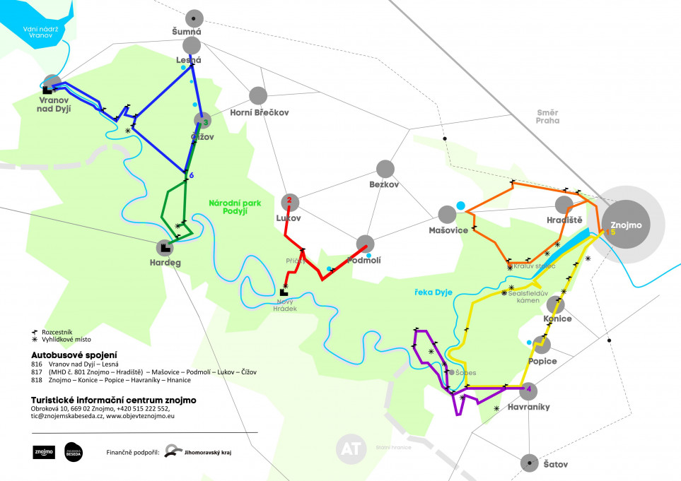
Lukov – Nový Hrádek – Podmolí
Length: 8 km (5 miles)
The route to the romantic ruins of Nový Hrádek (New Castle) begins in Lukov village, by the crossroads sign Lukov – bus. You can use bus number 817 to get there from Znojmo. For the first two kilometers follow the red trail. Go through the whole village first, then at the end turn left and walk for around 15 minutes until you get to Příčky crossroads sign. From here you must follow the red marks instead of the green ones. A beautiful footpath going through a forest interlaced with roots of trees will take you to the entrance of Nový Hrádek (New Castle), vast and well-kept ruins of a castle with a chemise wall.
To go back you need to take the same route to Příčky crossroads sign. Then, you will continue by following the green marks through the woods and across Žlebský potok (Žleby stream) to the Podmolí municipality. You can take bus number 817 to go back to Znojmo.
Čížov – Hardegg – Čížov
Length: 9 km (5.6 miles)
If you want to walk to the Hardegg Castle which lies right at the Austrian-Moravian river border created by river Dyje (Thaya), you should begin your journey in Čížov. To get there from Znojmo you can use bus number 817. Start at the crossroads sign in Čížov and follow blue marks. You should go past Pod Čížovem and Na Klepech crossroads signs. If you would like to enjoy the Hardegg scenery, turn to the right at the next crossroads sign called Hardeggská vyhlídka (Hardegg’s vantage point).
Then go back to the crossroads sign and continue following the blue trail to your right. You will go all the way to the border crossing which means you will need to get across a bridge over the river Dyje. On the other side of the valley, on the very top of the hill, you will see the Hardegg Castle.
On your way back to Čížov, you will first follow the green trail for 2 kilometers and you will get to Na Klepech crossroads sign. Then you will follow the blue trail for 1.5 kilometers all the way to Čížov. You can use bus number 817 to get back to Znojmo.
Havraníky – Devět mlýnů – Šobes – Havraníky
Length: 8 km (5 miles)
The route for one of the most visited vineyards in the Czech Republic starts at a crossroads sign on the periphery of Havraníky village. To get there from Znojmo you can go by bus number 818. First, follow the red tourist trail to Havranické vřesoviště (Havraníky Heath) and then, continue by following the green trail marks. You will get to the Pod Honigovou chatou (Below Honig’s Cottage) crossroads sign and by following a path along vineyards you will reach the Devět mlýnů (Nine Mills) vantage point. The vantage point offers you a beautiful view of famous Šobes vineyards in a meander of the Dyje river. Then you will continue to walk for a little less than one kilometer and you will get to Na Fládnické cestě (On Fládnická Path) crossroads sign, go round a chapel and continue for 600 meters to the river and to the Pod Šobesem crossroads. From this point on, follow the red tourist marks and cross a footbridge.
Here starts the Šobes route leading to the vineyard itself. During summer you can go there to taste local wines. Tourists who like a little challenge can climb further to Šobeská stezka (Šobes path) crossroads and then follow the yellow trail to Lipinská cesta (Lipina path). There you will find the blue trail and follow it back to Pod Šobesem.
To return to Havraníky you will follow the red trail for 2 kilometers. On your way there you should see Judexův mlýn (Judex Mill) and Havranické vřesoviště.
Sealsfieldův kámen – Popice – Znojmo
Length: 13 km (8 miles)
If you want to take a walk to a favorite viewpoint above the canyon of the Dyje river you should begin at the Znojmo – údolí řeky Dyje (Znojmo – valley of Dyje river) crossroads sign. From this valley located underneath Karolíniny sady (Karolína’s Garden) you will follow the yellow trail up to the Sealsfieldův kámen (Sealsfield’s Rock). The five kilometers long stretch is a picturesque forest track that will take you up and down alongside the flow of the river until it eventually leads you to the vantage point 80 meters above the meanders of Dyje river. Here you can enjoy the unique view of the canyon and admire the beauty of Podyjí National park. From the Sealsfieldův kámen crossroads you will follow the green trail to Popice village and its vineyards.
Then, follow the red trail for the last 4 kilometers of your journey. First, you will go through Konice village and then across Kraví hora (Cows Hill) which provides a beautiful view of Znojmo. Finally, you will get back to the same crossroads sign where your trip began. More ambitious tourists can extend their hike from Sealsfieldův kámen to Pod Novou cestou crossroads sign by following the yellow trail. On your way there you will pass the Papírna mill and get to Judexův mlýn (Judex Mill). After that you should follow the red trail, pass by Havranické vřesoviště and get to Popice village, where you will join the original route. This version is about 8.3 km longer than the original one.
Čížov – Vranov nad Dyjí – Čížov
Length: 20 km (12.4 miles)
The longest of these routes also begins at Čížov crossroads. First, you will follow the blue trail and you will get to Na Klepech crossroads sign, then, you will turn right to Pašerácká stezka (Smuggler Path) with red trail marks. At the first crossroads sign Ledové sluje you can choose to turn left to a vantage point near an obelisk. Then, you will pass Vranovská brána and Mostek hraběnky Heleny Mniszkové crossroads, and you will get to a crossroads near the river. Turn to the right and continue to go through Zadní Hamry alongside the river up to Vranov nad Dyjí.
On your way back cross the bridge near Vranov nad Dyjí – Benátky crossroads and follow the green trail for about 1.5 km. It will lead you to Zadní Hamry – lávka crossroads. For the next 2.5 km long stretch you will follow the red trail and connect to the same path leading to Vranovská brána. From here, go left, follow the yellow trail and pass the Lusthaus hunting lodge built in the middle of the 18th century. After 1 kilometer, turn right when you get to Pod Lesnou crossroads. The last 4.5 kilometers stretch is part of the blue trail. Follow the blue marks, pass Protržený rybník (pond) and Čížovské rybníky (Čížov ponds) to get back to the Čížov village.